


وصف لـ V-Navi
V-Navi - The full-featured navigation app for Android that brings you quicker to your goal! Works in conjuction with various apps (e.g., "Das Telefonbuch", "Das Örtliche", among others), even free of charge, as conditions may apply.
ATTENTION: Navigation can be started in Germany, Austria, Switzerland and optional in Western Europe.
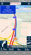
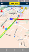
With the high quality traffic you will get a complete overview of the market. Traffic congestion traffic congestion avoidance. The V-Navi: you will thus always the best route. The traffic density is displayed in red, yellow, green in the map. Germany, Annual, 30 days free of charge with no obligation to buy. Internet connection is required.
The new version of V-Navi works with offboard maps (with limited functionality) to enable immediate navigation after download. The map data for Germany, Austria and Switzerland is downloaded once at the start of the first use of V-Navi (ca. 300 MB). Thereafter, an Internet connection is only necessary for a short time at app-startup.
HIGHLIGHTS:
- Current traffic situation in Germany (INRIX), traffic reports traffic congestion avoidance and traffic density display
- Offboard vector mode after first installation
- Lane info assistant
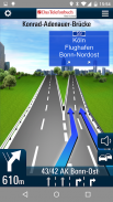
- Reality view (reality like display of turn actions on motorways)
- Map data is stored on the device
- Quick destination entry (address, points of interest (POIs), favorites, etc.)
- Updates free of charge
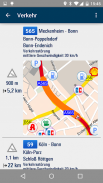
- Computation and display of alternate routes
- Display of speed limits and speeding alerts
- Support for portrait and landscape display
- Quick-Menu
- New and ergonomic menu
- Optimized map view
- Save & load itineraries
FUNCTIONS:
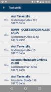
Destination entry:
- Address entry with an automatic pop-up list of cities, etc.
- Address search by country
- House-number-exact geocoding when online
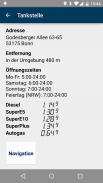
- POI search
- Destination selection directly on the map
- Entry of destination coordinates and crossroads
- Destination selection from a list of recent destinations and from the favorites list
- Use of contacts in the address book as destinations
Navigation:
- Profiles for car, pedestrians, recreational vehicles and caravans
- Adjustable routing: quickest, shortest
- Voice-guided navigation
- Spoken street names through text-to-speech
- Sinage display (motorway signs)
- Speed-dependent zoom and crossroad-zoom
- Stretch-block: Automatic route recalculation (e.g., for the next 0.5-10 km along the route to avoid a traffic jam)
- Avoidance of motorways, ferries, and tollways
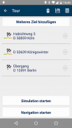
- Itineraries: Management of intermediate stops, saving and loading of itineraries
Map Display and Functionality
- View modes: 3D, 2D in the direction of travel, 2D North up
- Daytime and nighttime view modes, automatic switching (geodaylight)
- Route overview
- Display of POIs with setting of the destination directly from a POI icon on the map
CONDITIONS OF USE:
V-Navi may be used free of charge for a test period of 30 days. Numerous applications, such as the telephone directory apps "Das Telefonbuch" and "Das Örtliche" provide you with the means of continuing to use V-Navi free of charge by starting V-Navi directly from within the apps. Please consult the Conditions of Use in each of the respective apps.
The traffic data to 30 days (trial period) are free to use and are then as in-app purchase.
AVAILABLE in-app purchase options (for pricing, see under "In-App Purchases"):
- Traffic data for Germany (INRIX)
- Navigation und maps for Germany, Austria, and Switzerland (D-A-CH)
- Navigation und maps for Western Europe
The map data and navigation for Western Europe cover the following countries:
Germany (D),Austria (A),Switzerland (CH),Liechtenstein,Andorra,Belgium,Denmark,Finnland,France,Great Britain,Ireland,Italy,Luxemburg,Monaco,Netherlands,Norway,Portugal,San Marino,Spain,Sweden
See more at https://www.facebook.com/Map-and-Route-1454577274845960/
V-نافي - التطبيق الملاحة كامل المواصفات لالروبوت الذي تأتيك منه أسرع إلى هدفك! يعمل في الاقتران مع مختلف التطبيقات (على سبيل المثال، "داس Telefonbuch"، "داس Örtliche"، وغيرها)، حتى مجانا، كما يمكن أن تنطبق الشروط.
تنبيه: يمكن أن تبدأ الإنتقال في ألمانيا والنمسا وسويسرا واختياري في أوروبا الغربية.
مع مرور جودة عالية سوف تحصل على نظرة شاملة للسوق. الازدحام المروري الازدحام المروري تجنب. وV-نافي: صح التعبير وبالتالي دائما أفضل طريق. يتم عرض الكثافة المرورية باللون الأحمر والأصفر والأخضر في الخريطة. ألمانيا، السنوي، و 30 يوما مجانا مع أي التزام لشراء. مطلوب الاتصال بشبكة الانترنت.
النسخة الجديدة من V-نافي يعمل مع خرائط offboard (مع وظائف محدودة) لتمكين التنقل الفوري بعد التحميل. يتم تحميل بيانات الخريطة للحصول على ألمانيا والنمسا وسويسرا مرة واحدة في بداية أول استخدام للV-نافي (حوالي 300 MB). بعد ذلك، اتصال الإنترنت ضروري فقط لفترة قصيرة في التطبيق، بدء التشغيل.
يسلط الضوء على:
- حالة المرور الحالي في ألمانيا (INRIX)، وتقارير حركة المرور تجنب الاختناقات المرورية والكثافة المرورية عرض
- وضع ناقلات Offboard بعد التثبيت الأول
- معلومات لين مساعد
- عرض الواقع (واقع مثل عرض الإجراءات بدوره على الطرق السريعة)
- يتم تخزين بيانات الخرائط على الجهاز
- دخول سريع وجهة (العنوان، النقاط المثيرة للاهتمام (النقاط المهمة)، المفضلة، الخ)
- تحديثات مجانية
- احتساب وعرض طرق بديلة
- عرض حدود السرعة والتنبيهات السرعة
- تقديم الدعم لصورة والمناظر الطبيعية عرض
- سريعة-القائمة
- جديد والقائمة المريحة
- عرض الخريطة محسن
- حفظ وتحميل خطوط السير
وظائف:
دخول الوجهة:
- إدخال عنوان مع قائمة منبثقة تلقائية من المدن، الخ
- عنوان البحث حسب البلد
- الترميز الجغرافي البيت رقم وبالضبط عندما الانترنت
- البوي البحث
- اختيار الوجهة مباشرة على الخريطة
- دخول جهة تنسيق ومفترق طرق
- اختيار الوجهة من قائمة الوجهات الأخيرة ومن القائمة المفضلة
- استخدام الأسماء الموجودة في دفتر العناوين وجهات
ملاحة:
- لمحات عن السيارة والمشاة والمركبات الترفيهية والقوافل
- قابل للتعديل التوجيه: أسرع، أقصر
- الملاحة بالتوجيهات الصوتية
- يتحدث بها أسماء الشوارع من خلال تحويل النص إلى خطاب
- عرض Sinage (علامات الطريق السريع)
- تعتمد على سرعة التكبير ومفترق طرق التكبير
- تمتد كتلة: إعادة الحساب الطريق التلقائي (على سبيل المثال، لكم 0.5-10 القادمة على طول الطريق لتجنب ازدحام حركة المرور)
- تجنب الطرق السريعة والعبارات، وtollways
- مسارات: إدارة محطات وسيطة، وتوفير وتحميل خطوط السير
عرض خريطة وظيفة
- عرض وسائط: 3D، 2D في اتجاه السفر، 2D شمال يصل
- النهار وعرض ليلا وسائط، والتحول التلقائي (geodaylight)
- نظرة عامة على الطريق
- عرض النقاط المهمة مع تحديد الوجهة مباشرة من رمز POI على الخريطة
شروط الاستخدام:
V-نافي يمكن استخدامها مجانا لفترة اختبار لمدة 30 يوما. العديد من التطبيقات، مثل تطبيقات دليل الهاتف "داس Telefonbuch" و "داس Örtliche" توفر لك وسيلة للاستمرار في استخدام V-نافي مجانا من خلال البدء V-نافي مباشرة من داخل التطبيقات. يرجى الاطلاع على شروط الاستخدام في كل من التطبيقات منها.
البيانات المرورية إلى 30 يوما (فترة تجريبية) أحرار في استخدام وثم يتم والشراء داخل التطبيق.
تتوفر خيارات شراء داخل التطبيق (للتسعير، انظر تحت عنوان "داخل التطبيق مشتريات"):
- بيانات المرور لألمانيا (INRIX)
- الملاحة خرائط اوند لألمانيا، النمسا، وسويسرا (D-A-CH)
- الملاحة خرائط اوند لأوروبا الغربية
وتغطي بيانات الخرائط والملاحة لأوروبا الغربية والبلدان التالية:
ألمانيا (D)، النمسا (A)، سويسرا (CH)، ليختنشتاين، أندورا، بلجيكا، الدنمارك، Finnland، فرنسا، بريطانيا العظمى، ايرلندا، ايطاليا، لوكسمبورغ، موناكو، هولندا، النرويج، البرتغال، سان مارينو، اسبانيا، السويد
انظر للمزيد في https://www.facebook.com/Map-and-Route-1454577274845960/

V-Navi - معلومات APK
نُسخة APK: 4.9.7الحزمة: de.mapandroute.android.vnaviتطبيقات من الفئة نفسها
قد يعجبك أيضًا...


